The ASOR Field Archaeologist's Electronic Toolbox 
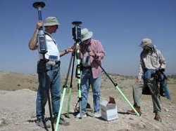
A few decades ago the tools used by field archaeologists were simple indeed--a trowel, a spade, a wheelbarrow, a bucket, a measuring tape, a line-level, a plumb-bob, a notebook, and a camera. Those days are now long gone! To meet best practices standards in our profession these days, field archaeologists need a lot more tools--the majority of them electronic in nature. Examples include hand-held data recording devices, laser measuring devices, LiDAR (optical remote sensing) technology, GPS units (Geographic Positioning System), low-altitude photography equipment, Ground-penetrating Radar (GPR), 3-D scanners, virtual comparison collections, froth flotation equipment, and much more.
 The purpose of the ASOR Electronic Toolbox is to offer ASOR institutions and researchers a place to share computer programs, data handling techniques and technologies, and specialized websites that may be of interest to dig directors, their core staffs, researchers and the general public. The Toolbox project will give priority to showcasing processes and procedures that have been developed and deployed by ASOR affiliated projects. ASOR-affiliated institutions and individuals who have developed essential electronic tools that fill critical needs of the modern archaeologist are encouraged to participate in the ASOR Electronic Toolbox project. Your tools will be showcased here and made available to the public through the ASOR web portal, in addition to your own websites.
Tools in the ASOR Field Archaeologist's Electronic Toolbox
 The search portal to The Digital Archaeological Atlas of the Holy Land (DAAHL). The DAAHL is an international project that brings together experts in information technology including Geographic Information Systems (GIS) and the archaeology of the Holy Land (modern Israel, Palestine, Jordan, southern Lebanon, Syria and the Sinai Peninsula) to create the first on-line digital atlas of the region held sacred to the three great monotheistic faiths - Judaism, Christianity and Islam. The searchable DAAHL database currently includes more than 27,000 archaeological sites and 65,000 site components. Search results can be displayed as full records in the DAAHL website or as maps for Google Earth.
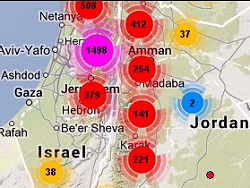 Jump directly to the Map Maker page in the Digital Archaeological Atlas of the Holy Land. Use this tool to make queries of sites in the DAAHL database by time period and/or site/feature type, and display the results on a Google Maps interactive map that includes site clusters and individual sites. Clusters can be clicked to zoom to the next level, displaying smaller clusters and individual sites. Hover over site points to see the site name. Use your computer's screen copy function to copy the map; then paste it into a graphics editing program and crop it to the map--then you can use the map in presentations or documents.
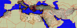 True Color Landsat 7 Images for the Middle East, Mediterranean, and North Africa. The images available here have been processed by the Geo-Archaeological Information Applications (GAIA) Lab at Arizona State University from 8 degree mosaics of multiple Landsat 7 "granules". Each 8 degree block was downloaded in Blue, Green and Red bands, and 4 degree pansharpening block images were applied. Then the large tiles were cut into slightly overlapping one degree blocks for the countries shown here, and color adjusted in Photoshop. Each tile comes with it's original geotiff image, a .tiff world file, a true color .jpg file and corresponding world file, and a projection (.prj) file.
 The Open Context Project helps archaeologists with data management by offering an open-access, Web-based venue for data publication. The University of California's California Digital Library provides Open Context with data preservation services, making it a citable and archived publication venue. The NSF (Archaeology Program) and the NEH (Digital Humanities program) both link to Open Context in reference to Data Management Plan requirements implemented in 2011.